Swimming spot: Three Shires Head, Peak District
Suzie Wheway of Peak Swims is your guide to a lesser-trodden walk to Three Shires Head, where you can enjoy a refreshing moorland plunge
Three Shires Head forms the meeting point of the three counties of Derbyshire, Cheshire and Staffordshire.
The River Dane, which runs through it, rises only 3km upstream on Axe Edge Moor.
The proximity to its source, and an elevation at 350m, means the water here stays cool all year, so it’s the perfect spot for a burst of cold when lowland waters lose their zing in summer, or early acclimatisation in autumn for the winter ahead.
While it can get busy on a hot day, this walk takes you via a lesser trodden path past hidden pools few people explore.
If you’re looking for peace and tranquillity, heading out early or planning your walk for a cloudy day could mean you get the place to yourself.
How to get to Three Shires Head
STEP 1
Our starting point is a large layby on the A54 overlooking the abandoned Reeve-edge Quarries and distinctive stone-built chimney of Danebower colliery.
From the layby, walk uphill keeping the chimney to your right and pass through a large metal farm gate onto a well-used track.
After around 100m take a sharp right hand turn switching from stone track to a grassed footpath. This will cut across and down the hillside below the layby, you’ll pass the chimney again uphill to your right.
If you’re taking your furry friend along please note that there are restrictions in place to protect moorland habitats. Dogs must stay on public rights of way and stay on a lead at all times.
STEP 2
Continue down the valley. The stream to your left will gradually widen and begin to gently tumble. The hill to your right is studded with purple foxgloves in June and July and taken over by the heady scent of bracken in August and September.
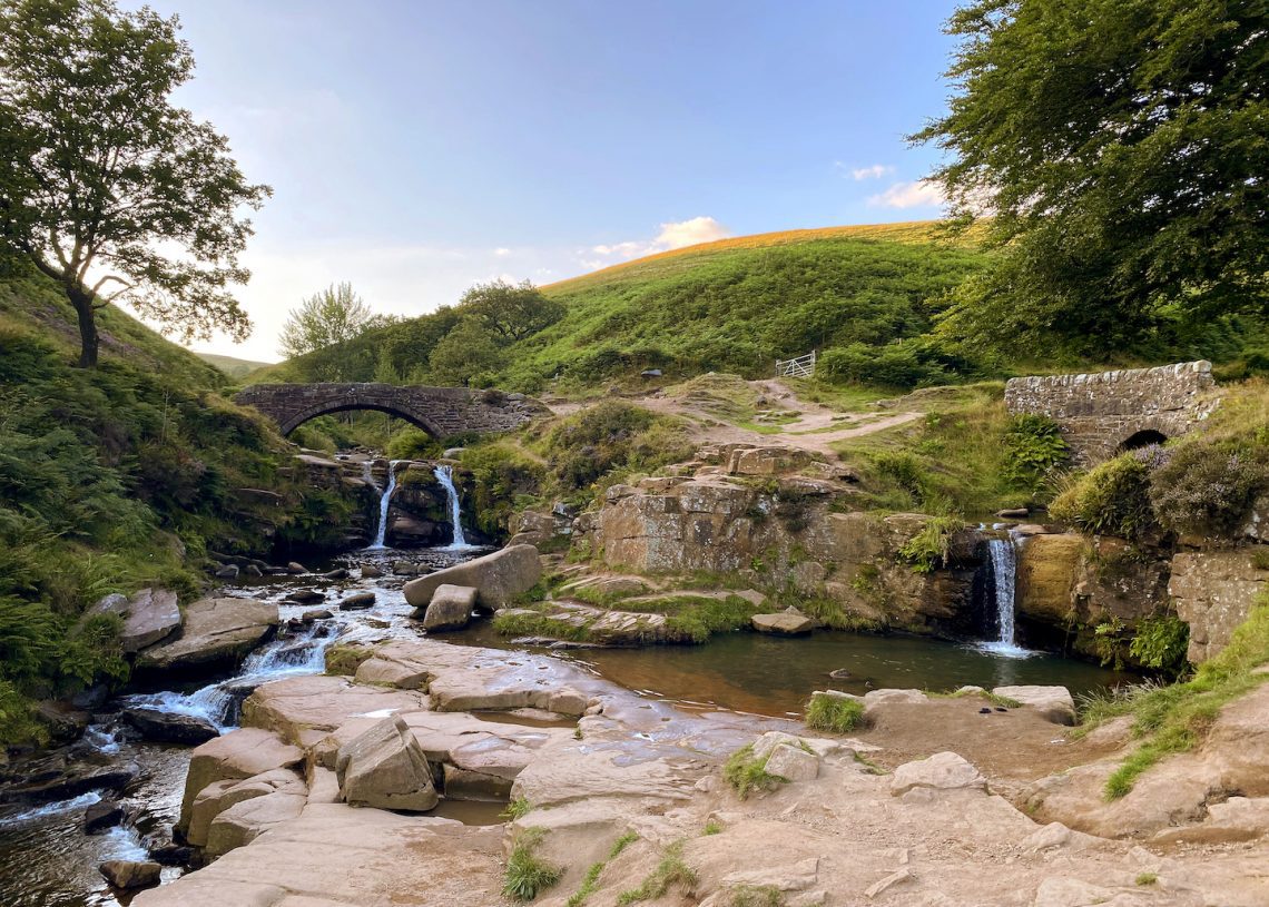
Look out for pools along this stretch, many are suitable for dipping with grassy banks on either side. After around 2km you’ll reach the iconic packhorse bridge.
STEP 3
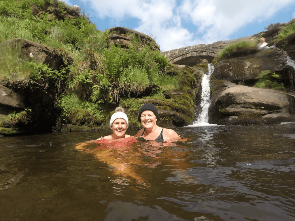
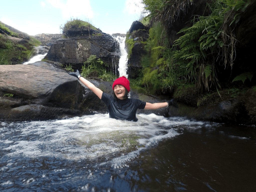
Below the bridge lies Panniers Pool, where ponies were brought to water along the four ancient packhorse routes that meet here.
There are two main pools: a shallower pool to the left is perfect for acclimatisation and a shoulder massage while the main pool has a double cold jacuzzi fall. You’ll be surrounded by the rich greens of moss, grasses and ferns and the ruggedness of eroded sandstone blocks.
Water shoes are recommended to aid movement across the stony floors in the pools and rock shelves. There is a larger pool and fall 50m downstream and a hidden deep plunge pool just upstream of the bridge that few people explore.
STEP 4
The return leg is the perfect warm-up to shake off any chills from your moorland plunge.
From the bridge take the path through a large metal gate to ascend a narrow valley with a stream to your right. At the next junction take the left hand fork keeping the stream to your right and then bear left onto a tarmacked road towards Black Clough Farm.
Walk past the farm, through a metal farm gate and bear diagonally across the fi eld to a large gate through a dry stone wall. Turn left here onto a clear stone track.
In spring this section of grassland is alive with the sounds and swooping flight of ground nesting birds including curlew, lapwing and skylark.
STEP 5
At the edge of the quarry bear left at the first large rubble pile and follow a well-trodden path through the quarry. This landscape is wholly manmade but is being beautifully reclaimed by nature as bilberry and heather colonise these rocky mounds.
Cross the stream via stepping stones and ascend to a small sheepfold. Follow the path to the left through heather clad mounds and retrace your earlier steps back to the start point.
Safety point: Be weather aware
This is an elevated moorland environment and weather can change quickly. Always check the forecast before you head out and be aware it could be significantly cooler and breezier here in comparison to where you’ve travelled from. Make sure you have appropriate clothing for the day including a waterproof layer and enough layers to help you warm up after you swim.
Getting there
There is space for a dozen or so cars in the lay-by at the start point on the A54. There is another lay-by down the hill and on the two small roads, which cut between the A54 and A53 to the north. I recommend using the Ordnance Survey White Peak OL24 map for this route.
Go for a wild swimming experience with Suzie of Peak Swims: peakswims.co.uk
This article is from the September issue of Outdoor Swimmer. Click here to subscribe to the magazine.
Outdoor Swimmer
Outdoor Swimmer is the magazine for outdoor swimmers by outdoor swimmers. We write about fabulous wild swimming locations, amazing swim challenges, swim training advice and swimming gear reviews.